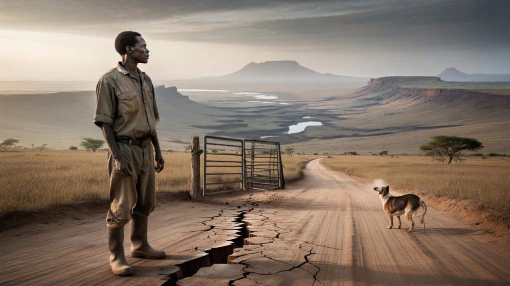
A grey sky, a dusty road, a farmer watching the clouds with a quiet, tired hope. But under his feet, the ground is stretching, almost breathing. Tiny fractures open in the soil, then close again. A metal gate vibrates for no reason. A dog starts barking at nothing.
There is no dramatic movie crack racing across the Earth. No neat line where Africa suddenly snaps in two. What’s happening is slower, deeper and stranger than that. Plates shift at the speed your fingernails grow. Rock turns almost liquid. The continent, little by little, is being reshaped.
And one of the biggest changes is already happening, out of sight, under the surface.

The quiet tear running through a living continent
Stand on a hill in Kenya’s Rift Valley at sunrise and the landscape tells you something is off. The horizon isn’t smooth. It’s broken, stepped, like a giant staircase falling away towards Tanzania and Ethiopia. Volcanoes rise from the plains. Lakes lie in long, narrow basins, as if poured into a crack that never really closed.

Geologists call this whole zone the East African Rift. It’s not a single line on a map, but a wide, messy scar running thousands of kilometres from the Red Sea down towards Mozambique. Every few months, small earthquakes ripple along it, weak enough that most people just feel a shiver in a window frame.
From space, satellites detect something your eyes can’t see: the land on either side of this rift is drifting apart by a few millimetres every year. Slow. Relentless. Very real.
One story keeps coming up when locals talk about this invisible pulling apart. In 2018, after days of rain in Kenya’s Narok County, a gaping crack suddenly opened in the ground, slicing through a busy road. Images went viral: tarmac hanging in mid-air, a car half swallowed, families staring into a trench several metres deep.
Experts rushed to explain that this crack was partly linked to erosion and heavy rain, not an overnight “continent splitting”. Still, for people who live there, that nuance doesn’t erase the shock of watching the land literally open in front of them. One farmer lost a section of his field in a single afternoon.
Those moments are rare, yet they expose something that’s constant. Beneath the farms and villages, hot rock from deep inside the Earth is rising and pushing. It weakens the crust, carves faults, and lays the groundwork for a future ocean. The scary part isn’t that Africa will split tomorrow. It’s that the process is already in motion, and it doesn’t stop for our comfort.
Deep under East Africa, something like a slow-motion engine is running. A huge plume of hotter-than-usual mantle rock is rising from the depths, spreading out under the continent like thick, simmering soup under a lid. Where that heat pools, the crust above thins and stretches. That’s how rifts are born.
Over millions of years, this stretching can go through stages. First you get cracks and faults on the surface. Then basins form and fill with lakes and volcanic ash. Eventually, if the stretching continues, the crust can break completely, letting seawater rush in and form a new ocean basin. The Red Sea and the Gulf of Aden show what this looks like at a more advanced stage.
Right now, the East African Rift is in that in-between phase. Not just theory on a blackboard. Not yet an ocean. That’s why scientists say Africa is slowly splitting apart, but insist that the “event” is anything but sudden.
The hidden movement under your feet
There’s one precise thing already happening beneath the surface that changes the story from distant future to quiet present: magma is on the move. Not only in classic cone-shaped volcanoes, but in long, underground sheets and fingers called dykes. These molten intrusions creep sideways through the crust, prying it open bit by bit.
In places like Ethiopia’s Afar region, researchers have directly watched this process with GPS and satellite radar. In 2005, a dramatic dyke intrusion opened a 60‑kilometre-long crack in just a few days, dropping the ground by several metres in places. The lava stayed mostly hidden below. What the world saw on the surface was only the tip of a huge, underground reshaping.
This is where the “Africa is splitting” headlines come from. The real action is these repeated, silent injections of magma at depth. They widen the rift without a Hollywood-style earthquake. One day you have intact crust. Long after, you have two sides with a thinning, weakening zone between.
On a human level, that slow tearing creates a weird mix of anxiety and routine. People in Rift Valley towns feel small tremors and shrug them off. Children in schoolyards learn to name the nearby volcanoes like they’re old neighbours. Life goes on, even as the ground quietly changes character below them.
We’ve all had that moment where you’re told something huge is happening “over geological time” and your brain just checks out. Africa’s potential split can feel like that: too big, too slow, easy to file away under “not my problem”. Yet for local communities, the changes tied to this deep process are already practical: which areas flood, which roads crack, where geothermal plants can tap into underground steam.
One concrete way scientists are tracking the rift’s evolution is with dense networks of GPS stations. These small metal boxes, often sitting on concrete pads in dusty fields, quietly record their own position several times a day. From their tiny shifts, researchers can tell whether the land is stretching, twisting, or sinking by millimetres per year.
Satellite radar adds another layer. By comparing radar “snapshots” of the ground over months or years, computers can detect uplift or subsidence that the naked eye would miss. That’s how we know that in parts of Ethiopia and Tanzania, the surface is slowly bulging as magma accumulates, or sagging where the crust is thinning.

The data is dry, but the stakes aren’t. Where the ground sags, drainage changes, which alters where water collects after heavy rain. Where it uplifts, stress on faults can adjust, changing earthquake patterns. The invisible movement beneath the surface shapes very visible risks above it.
Soyons honnêtes : personne ne lit des courbes GPS au petit déjeuner. People need simpler cues. That’s why many teams now work directly with communities, mapping the places where cracks appear in walls, where boreholes dry faster, where hot springs shift temperature. They cross-check those stories with the hard numbers.
For locals, one useful habit is to treat small anomalies less as spooky one-offs and more as part of a living system. A new fissure in a field, a strong smell near a spring, unusual dead fish in a rift lake: all these can be logged, photographed, reported. Village elders often remember “the last time this happened” better than any archive.
None of this gives power over tectonic plates. What it does give is a thread of understanding. Instead of a vague fear that “the continent is breaking”, communities gain a clearer picture: this valley is stretching, that hill is stable, this area is heating up underfoot. In a region where nature can feel both generous and brutal, that pattern matters.
Scientists working in the rift repeat a simple idea: adaptation starts with listening to the land. Not in a mystical way, but through a mix of stories and sensors. When satellite images show the ground in one village sinking by 5 mm a year, and residents say their wells are cracking, that’s not coincidence. It’s a signal.
One geophysicist based in Nairobi summed it up to me like this:
“The rift doesn’t wake up one morning and decide to tear Africa in half. It whispers for thousands of years. Our job is to learn its language while there’s still time to rearrange where and how we live.”
*That language is already reshaping policy.* Governments in Kenya and Ethiopia increasingly weigh rift data when planning new roads, pipelines or geothermal plants. They look at fault maps, at subsidence zones, at the track record of local quakes.
- Magma is already intruding under East Africa, widening the rift quietly.
- GPS and satellites prove the land is stretching by millimetres each year.
- Local stories about cracks, springs and tremors help ground the science.
- Future oceans grow from these slow, present-day shifts in the crust.
- Living with the rift means blending hard data with everyday observation.
A future ocean hiding in slow motion
The idea that a new ocean could one day flood through East Africa sounds like pure science fiction. Yet geologically, that’s exactly what a mature rift can become. Look at the Atlantic: it began as a rift, once pulling apart the supercontinent Pangaea. For millions of years, it was just a line of stretched, cracked rock, not a drop of seawater in sight.
Today’s East African Rift is somewhere along that same path, far behind the Red Sea but heading in a similar direction. The deepest basins already host long, narrow lakes like Tanganyika and Malawi, filled with unique fish species and bordered by steep, unstable slopes. Those lakes mark the lowest, thinnest parts of the stretched crust.
If the stretching continues for tens of millions of years, those basins may connect and sink deeper, eventually allowing water to flow in from the Indian Ocean. Long after our time, a slim new ocean arm could cut through what is now highland and savannah. The land we walk on would become seabed. For now, that ocean exists only as stress lines and simmering rock.
For people living there today, the story is less about distant oceans and more about the rhythm of eruptions, quakes and new energy sources. Geothermal plants in Kenya’s Olkaria region already pull steam from the rift’s hot heart to power cities. That same heat sometimes boils mud pools overnight or shifts geysers unexpectedly.
One emotional undercurrent you sense when talking to residents is a mix of pride and unease. Pride in living in a place where Earth’s forces are so raw and visible. Unease because there’s no off switch. A calm decade can be followed by a restless year of shaking and ash. *The map is not fixed; it’s a draft in progress.*
When people say “Africa is splitting apart”, it can sound like a disaster headline. On the ground, it’s more complicated, more ordinary, and in a way more intimate. The real story is not one giant crack, but countless tiny movements, most of them hidden from view. The continent is not breaking like a plate dropped on the floor. It’s stretching, sagging, relighting old volcanic lines, quietly preparing a new shape.
That hidden change is already here in the way some roads warp, in the way seismic stations flicker online after a tremor, in the way schoolchildren in Nakuru know more volcano names than capital cities. Whether we live in Nairobi or Newcastle, the idea that a continent can re-draw itself in slow motion has a way of shrinking our own timelines. It reminds us that the ground we call solid is really only pausing between movements.

Maybe that’s the strangest part: we are living in the early pages of a story whose ending will only be read by other species, on other shorelines. The rift grows, magma creeps, plates drift on a mantle we’ll never see. And somewhere under a Kenyan farmer’s boots, the first outlines of a future ocean floor are already taking shape.

| Point clé | Détail | Intérêt pour le lecteur |
|---|---|---|
| Un rift bien réel | Le Rift est-africain s’étend de la mer Rouge au Mozambique, avec un étirement mesurable de quelques mm/an. | Comprendre que “l’Afrique qui se fissure” n’est pas un mythe, mais un processus en cours. |
| Magma sous la surface | Des injections de magma (dykes) ouvrent silencieusement la croûte sans forcément produire d’éruptions visibles. | Prendre conscience que le changement géologique le plus fort se joue hors de vue. |
| Un futur océan | Sur des dizaines de millions d’années, ce rift pourrait évoluer vers un nouvel océan intérieur. | Se projeter dans la très longue durée et mesurer la fragilité apparente de nos cartes actuelles. |
FAQ :
- Is Africa really going to split into two continents?Yes, in geological terms the East African Rift is a zone where the African Plate is slowly tearing. If the process continues for tens of millions of years, it could create a separate plate and a new ocean basin.
- Will this happen suddenly in a massive, catastrophic event?No. The movement is extremely slow, usually a few millimetres per year. There can be short, intense episodes of earthquakes or fissuring, but the overall break-up is a very gradual process.
- Is the big crack seen in Kenya proof that the continent is breaking now?That crack showed how active and fragile parts of the rift zone are, but it was influenced by erosion and heavy rain as well as tectonics. It’s a symptom of an active rift, not a single “moment of breakup”.
- Are people living in the Rift Valley in constant danger?They face real risks from local earthquakes, landslides and volcanic activity, which vary a lot from place to place. Daily life continues, but building codes, land-use planning and monitoring are crucial in the most active areas.
- How do scientists know the ground is moving by just a few millimetres?They use high-precision GPS stations and satellite radar to measure tiny changes in position and elevation over time. Combined, these methods can detect motion smaller than the thickness of a fingernail each year.