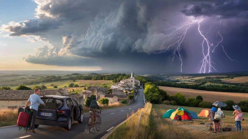
Warmer air, packed trains and full campsites were meant to signal a taste of summer. Instead, a large part of the country is bracing for violent thunderstorms, intense lightning and sharp changes in weather, just as millions hoped for four calm days outdoors.
Summer warmth sets the stage for a stormy weekend
Friday is giving many French residents exactly what they wanted: blue skies, warm sunshine and temperatures ranging from the high teens to the low 30s Celsius, depending on the region.
This early taste of summer is not just pleasant; it is also exactly what fuels the coming instability. According to French forecasters, hot air at low levels is clashing with much cooler air higher up in the atmosphere.

The sharp contrast between hot ground-level air and cooler air aloft is triggering a strong storm system over France.

This contrast encourages convection, the upward movement of warm, moist air that builds towering storm clouds. By Saturday afternoon, that process should be well underway.
The first storms are expected over higher ground. Meteorologists warn that the Pyrenees and the Massif Central will be the first areas hit, with cells then able to spread out towards the north-east plains if conditions line up.
Hikers, campers and cyclists planning outings in these regions on Saturday are urged to keep a close eye on the sky and on updated forecasts. Storms may flare up quickly, with little warning, and can be intense on a local scale even if national maps look relatively calm.
Saturday: a split personality day
Saturday morning should still look reassuring in much of France. Sunshine will hold on for several hours across many regions, and temperatures will once again feel almost summerlike.
The real change is expected in the afternoon, when storms are set to erupt across the eastern half of the country.
Forecasters expect thunderstorms to hit not only the mountains but also the lowlands across eastern France. That includes parts of the northeast, central-east and areas near the Alps. The storms could bring heavy downpours, frequent lightning and gusty winds.
These storms are expected to weaken overnight, but the air mass above France will stay unstable. That means Sunday will not bring a full return to calm conditions.
Sunday: storms spread, 61 départements on orange alert
On Sunday, unsettled weather is forecast over almost the entire country. Only a few corners of France are likely to stay largely sheltered: the Mediterranean coastline and the far tip of Normandy should remain less affected.
During the morning, storms may be more scattered and focused on certain areas such as Haute-Marne, Bas-Rhin and Cantal. As daytime heating kicks in again, activity is forecast to ramp up strongly in the afternoon.
Storms are expected to form and intensify from the Lyon and Grenoble regions towards the Alps, and along the Swiss and German borders. The Massif Central should once again act as a magnet for thunderclouds.
A total of 61 départements have been placed under orange-level thunderstorm vigilance, from the Ardennes down to Haute-Garonne and the Mediterranean foothills.
The orange alert means a significant risk of dangerous weather, including strong lightning, brief but intense rainfall, local flooding, hail and powerful wind gusts. Residents in these areas are urged to follow official vigilance bulletins and avoid unnecessary travel during the peak of the storms.
Areas under orange storm alert
The following départements are currently flagged as being at higher risk of thunderstorms this weekend:
 Long considered “corny,” this hairstyle is actually the one a hairstylist recommends most after 50
- North and north-east: Ardennes, Aube, Marne, Haute-Marne, Meurthe-et-Moselle, Meuse, Moselle, Bas-Rhin, Haut-Rhin, Vosges
- East and central-east: Côte-d’Or, Doubs, Jura, Nièvre, Haute-Saône, Saône-et-Loire, Yonne, Territoire de Belfort, Ain
- Massif Central and nearby: Allier, Ardèche, Cantal, Drôme, Isère, Loire, Haute-Loire, Puy-de-Dôme, Rhône, Savoie, Haute-Savoie
- Provence and south-east: Alpes-de-Haute-Provence, Hautes-Alpes, Alpes-Maritimes, Bouches-du-Rhône, Var, Vaucluse
- South-west and Atlantic façade: Charente, Charente-Maritime, Corrèze, Creuse, Dordogne, Gironde, Landes, Lot-et-Garonne, Pyrénées-Atlantiques, Deux-Sèvres, Vienne, Haute-Vienne
- Occitanie and Pyrenees: Ariège, Aude, Aveyron, Gard, Haute-Garonne, Gers, Hérault, Lot, Lozère, Hautes-Pyrénées, Pyrénées-Orientales, Tarn, Tarn-et-Garonne
These areas form a broad diagonal band stretching from the north-east border regions down across central France and into the southwest and Mediterranean hinterland.
Early next week: instability lingers but intensity drops
As the long weekend ends, the threat level is expected to ease, though the weather will not fully settle. On Monday and Tuesday, showers will be widespread in many regions, with occasional rumbles of thunder still possible.
Forecasters expect fewer dangerous phenomena early next week, as the atmosphere gradually loses energy.
The risk of large hail, severe winds or widespread lightning outbreaks should decline. Instead, many places may face passing showers, some short thunderstorms and cooler, fresher air compared with the start of the weekend.
For those who delayed trips to avoid the worst of the storms, the beginning of the week may offer more manageable, if still changeable, conditions.
Practical advice if you are in the alert zones
Authorities are urging residents and visitors in the 61 départements on orange alert to stay cautious and adapt their plans. Some basic actions can significantly reduce risks during severe thunderstorms.
- Postpone mountain hikes, long bike rides or water sports if storms are forecast nearby.
- Avoid sheltering under isolated trees or metal structures when lightning is active.
- Unplug sensitive electronics if strong lightning is expected and you are at home.
- Do not attempt to drive through flooded roads, even if the water seems shallow.
- Secure loose objects on balconies, terraces and gardens that could be blown away by gusts.
People camping or attending festivals and outdoor events are particularly exposed. Tents offer almost no protection from lightning or falling branches. Event organisers may need to adjust schedules, pause concerts or move crowds under solid structures as cells approach.
Why warm spells so often end with storms
The current situation over France is a textbook case of how early-season warmth can flip into intense thunderstorms. During sunny days, the ground heats up quickly, warming the air in contact with it. Warm air is lighter and starts to rise.
When that rising air meets a layer of colder air higher in the atmosphere, the difference in temperature and humidity helps build tall clouds. These are known as cumulonimbus, the classic anvil-shaped storm clouds that can tower more than 10 kilometres into the sky.
Inside these clouds, powerful updrafts, downdrafts and collisions of ice particles create the electrical charges that lead to lightning.
The same process can generate heavy rain over a small area in a short time, causing flash flooding in streets and valleys, while nearby towns stay nearly dry. That is why forecasts sometimes mention a “risk of locally strong storms” rather than widespread severe weather everywhere.
What orange vigilance actually means
France uses a colour-based vigilance system to signal weather risks to the public. Green means no particular risk, while yellow signals conditions that deserve attention but are not expected to be dangerous for most people.
Orange is the second-highest level. It is used when weather events are strong enough to threaten safety or disrupt daily life. That can include power cuts, blocked roads, flooded basements, damaged crops or falling branches.

During an orange alert, authorities recommend limiting outdoor activities during the most active storm periods, especially in forests, mountains or open fields, and staying informed through regular forecast updates and smartphone alerts.