The message popped up quietly on a Sunday night: a small alert from a weather researcher in Tromsø, just above the Arctic Circle. A strange bulge in the data. Sudden warming at high altitude. Winds over the pole beginning to twist in ways they shouldn’t this early in the year.
Outside, the town was wrapped in that deep winter blue, the kind that seems to swallow sound. Inside the lab, screens glowed with looping animations of swirling air currents, like ink dropped into water. Lines that usually circled the Arctic neatly in February were fraying, splitting, reaching south.
One of the meteorologists leaned back, rubbed tired eyes and muttered: “If this locks in… early February could be a real turning point.”

Nobody in the room argued.

The Arctic’s invisible engine is starting to sputter
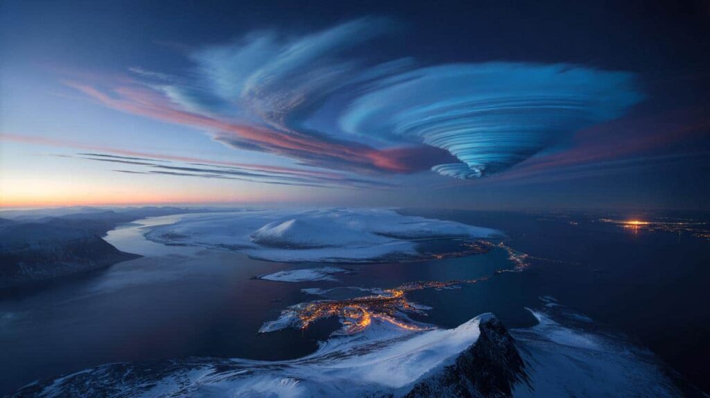
High above the North Pole, far above commercial jets and storm clouds, sits a wild and usually well-contained beast: the polar vortex. Most winters, it spins like a tight, icy halo around the Arctic, keeping the cold air mostly locked in, like a lid on a freezer.
This year, meteorologists tracking that halo are watching it bend and twist in new ways as early February approaches. The vortex is wobbling, stretching like chewing gum, threatening to spill its contents southward.
On their models, that wobble appears as jagged red and blue bands punching north and south. On the ground, it could translate into something much more tangible: freak cold snaps, late snowstorms, or bizarre temperature swings in places that thought winter was nearly done.
A few winters ago, Texas found out what happens when the Arctic’s “lid” fails. In February 2021, a disrupted polar vortex helped unlock a brutal cold wave that pushed deep into the southern United States, collapsing parts of the power grid and leaving millions without heat.
People slept in cars to stay warm. Water pipes burst across neighborhoods built for mild winters, not sub-zero nights. That crisis started with strange curves on upper-atmosphere charts that looked eerily similar to the ones some researchers are staring at again this year.
No one is saying a repeat is guaranteed. Weather is messy, chaotic, stubbornly resistant to straight-line forecasts. Yet many of the same ingredients are on the table, and they’re arriving a few weeks earlier in the season than many forecasters would like.
Meteorologists talk about the Arctic atmosphere like an engineer talks about an engine. You’ve got the polar vortex above, sea ice and ocean temperatures below, and a narrow “jet stream” of fast-moving air in between. When those parts are balanced, winter patterns tend to be more predictable: cold stays north, milder air holds south, storms track along familiar lanes.
As the Arctic warms roughly four times faster than the rest of the planet, that balance is loosening. Differences between north and south temperatures are shrinking, and the jet stream can start to wander, forming huge loops. Early February is shaping up as one of those moments when all of this can suddenly snap into a new configuration.
*That’s why seasoned forecasters are suddenly watching February like hawks, not just for the next snow day, but for signs that the Arctic’s long-term stability is shifting beneath our feet.*

What this turning point could look like from your window
So what does an “Arctic atmospheric turning point” actually feel like if you’re not staring at satellite maps? Sometimes it’s dramatic: a week of bone-deep cold after shirtsleeve weather. Other times, it’s quietly unsettling, like rain hammering down on frozen ground that should be holding dry, powdery snow.
Meteorologists tracking this early-February setup are flagging three possibilities: an intense cold plunge into mid-latitudes, a flip to weirdly warm conditions in the far north, or a whipsaw between both in quick succession. None of those are abstract if you own a drafty house, rely on winter crops, or manage a city’s roads.
One tip from forecasters sounds almost too simple: pay attention to the forecast beyond your usual two- or three-day glance. In weeks like this, the seven- to ten-day outlook stops being background noise and starts being a real planning tool.
We’ve all been there, that moment when you scroll past a weather warning thinking, “They always exaggerate.” That works until the day it doesn’t. A farmer in northern France learned that lesson last year when a late-season cold blast killed off early buds on his apple trees. The models hinted the freeze might come, but the winter had been so mild he planted anyway.
During a polar-vortex wobble, cities can face their own version of that mistake. A transport manager in Warsaw told me about scrambling to find road salt after an unexpected deep freeze hit in late February, right when they’d quietly shifted budgets toward spring maintenance. “We thought winter was winding down,” he said. “Then suddenly we were right back in January.”
These are the tiny human frictions hidden inside those big Arctic charts: kids’ school days canceled, heating bills spiking, supply chains snapping under icy roads or flooded rail lines.
Let’s be honest: nobody really reads every climate bulletin or atmospheric briefing, even during a volatile winter. Yet during weeks like early February, there are a few low-effort habits that quietly pay off.
“People think of the polar vortex as a headline event,” says Dr. Lena Sjöberg, a Swedish atmospheric scientist. “I think of it as background music. When the music changes, everything you feel on the ground – storms, cold blasts, strange warmth – can change with it.”
- Scan regional forecasts twice a week during the first half of February, not just your local app. It gives context to sudden shifts.
- Keep one simple “cold shock” kit ready: extra blankets, batteries, a way to charge phones, basic food that doesn’t need cooking.
- Watch how often your local meteorologists mention the jet stream or polar vortex. When they keep coming up, volatility is usually higher.
- Notice whether your winter feels “stop-start” or oddly calm. That lived sensation can match the atmospheric story more than you’d think.
- Talk to older relatives about winters they remember. Their stories help ground climate talk in real, shared memory.
The bigger question hiding behind this February
Beyond the immediate forecasts and cold snaps, early February is raising a quieter, heavier question: what happens when the Arctic’s “normal” stops being normal at all? Meteorologists are trained to think in decades, builders in years, families in days. When the background climate shifts, those timelines start crashing into each other.
A teacher in Montreal told me her students now expect at least one wildly strange winter week every year: snow in torrents, or almost none at all; ice rain where their parents remembered sledding. Climatologists don’t find that surprising anymore. For them, the Arctic’s accelerating warming – and the way it warps the jet stream – is the real headline, not just the occasional brutal cold wave trending on social media.
 Meteorologists warn an abnormally early Arctic failure is emerging just days before February
As this early February unfolds, you don’t need to understand every swirl on the map to feel what’s at stake. You just have to look out the window, talk to your neighbors, and notice which seasons still feel familiar – and which ones increasingly don’t.

| Key point | Detail | Value for the reader |
|---|---|---|
| Arctic instability is rising | Early February could bring a significant wobble in the polar vortex and jet stream | Helps you anticipate unusual winter patterns in your area |
| Impacts are very local | From power grids to crops and daily commutes, small shifts aloft trigger real-life disruptions | Encourages practical preparation rather than abstract worry |
| Simple habits matter | Regular forecast checks, basic home readiness, and listening to local experts | Gives clear, low-effort steps to stay safer and less surprised |
FAQ:
- What exactly is the polar vortex everyone talks about?It’s a large, persistent low-pressure system of cold air high over the Arctic, surrounded by strong winds. When it’s stable, it keeps severe cold near the pole. When it weakens or splits, that cold can spill south.
- Does a polar vortex disruption always mean extreme cold where I live?No. Some regions get intense cold, others stay mild or even warm. The jet stream’s exact wiggles decide who gets what, which is why local forecasts still matter more than headlines.
- Is climate change causing these winter extremes?Most scientists agree a rapidly warming Arctic is changing the way the jet stream and polar vortex behave. That doesn’t cause every individual storm, but it loads the dice toward more frequent swings and surprises.
- Should I be stockpiling for early February?A full-blown stockpile usually isn’t necessary. A few days of extra food, medicine, and a backup heat or light source are enough for most people and also help during other types of storms.
- How long could this “turning point” last?The specific early-February pattern shift might unfold over several weeks, but the underlying trend of a less stable Arctic is multi-decade. This month is more like a flashing warning light than a one-time event.