The first time you see it, you don’t quite believe your eyes.
A long, raw scar in the earth, slicing through fields and dirt roads in southern Kenya, as if some giant hand had dragged its nails across the landscape. Villagers walk carefully along the edge. A bus stands abandoned where the ground suddenly dropped. A woman in a bright kanga quietly films the crack with her phone, already halfway to going viral on TikTok.
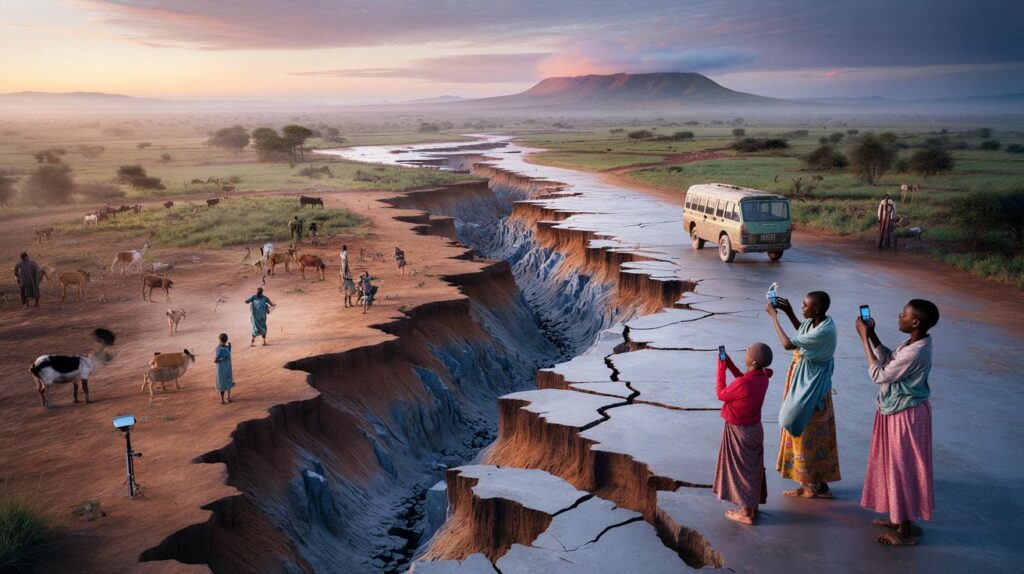
On the horizon, life goes on. Goats graze, kids kick a plastic ball, a boda-boda driver weaves around the new gap as if it were just another pothole.
What you’re looking at is not a movie scene. It’s one of the places where Africa is, very slowly, tearing itself apart.
And the numbers say this split is already measurable — right now.

A continent slowly pulling apart, millimeter by millimeter
Stand in the Great Rift Valley at dawn and you can almost feel it.
The air is still, pink light pools around the volcanic hills, and the ground beneath your feet is literally moving. Not fast enough to notice in a day, or even in a lifetime. But GPS satellites quietly track it, like a patient heartbeat.

Geologists talk about the East African Rift as if it were a living thing.
It stretches over 3,000 km from the Afar region in Ethiopia, through Kenya and Tanzania, down toward Mozambique. Two massive tectonic plates are tugging in opposite directions, the African continent thinning and stretching like warm caramel. The split we associate with distant futures — new seas, new coastlines — has already begun in the numbers.
If that sounds abstract, picture this.
In northern Ethiopia, in the Afar Depression, scientists have installed high-precision GPS stations anchored into solid rock. These devices quietly send data to satellites, day after day, year after year. When researchers compare those readings, they see that some points on the continent are drifting apart by a few millimeters each year.
A few millimeters doesn’t sound like much.
But over ten years, that’s centimeters. Over a century, it’s the width of your hand. Extend that over millions of years and you get something enormous: a whole new ocean basin opening up between what we now call East Africa and the rest of the continent. That’s the mind-bending part — the process is slow for humans, but fast on a geological clock.
The logic behind all this is brutal and simple.
Earth’s crust is not a solid shell; it’s a cracked mosaic of tectonic plates floating on a hot, convecting mantle. Under East Africa, that mantle is rising, hotter and less dense, bulging the crust upward and stretching it until it breaks along faults. When rock stretches, it fractures. When it fractures, it moves.
Every small earthquake, every micro-shift picked up by seismometers, adds another data point.
This is how scientists know the African plate is splitting into two: the Nubian Plate to the west and the Somali Plate to the east. *The “future” map of Africa exists already in equations, sensors, and satellite tracks.* The drama we imagine happening in some distant sci‑fi timeline has, quietly, already begun.
How scientists “watch” a continent split in real time
There’s something strangely domestic about how we track such a colossal event.
No grand observatories with smoking volcanoes framed in the window. Behind the science, you often find a metal box the size of a suitcase bolted to lonely rock, a solar panel, a small antenna pointing to the sky. That’s a GPS station. And that’s one of the main ways we know Africa’s split is measurable today.

These stations constantly ping satellites, calculating their exact position again and again.
Tiny shifts — half a millimeter here, one millimeter there — get logged. Over years, a pattern emerges. Lines on a map show parts of East Africa creeping away from the rest. It’s slow, it’s invisible to the naked eye, and it’s very, very real.
We’ve all been there, that moment when a big, distant risk feels too abstract to take seriously.
For many people living along the rift, the idea of a continent ripping apart in “millions of years” lands in the same mental folder as asteroid impacts and heat death of the universe. Life is about rains, harvests, fuel prices, school fees.
Let’s be honest: nobody really checks tectonic data every single day.
That sense of everyday normality is understandable, especially when real emergencies come in the form of flash floods or droughts, not geological charts. Yet the split has more immediate faces: recurring small earthquakes, volcanic activity in places like Nyiragongo in the DRC, and ground deformation that can crack roads, pipes, houses. It’s not the dramatic Hollywood canyon opening under your feet. It’s the slow, tiring negotiation between people and a restless ground.
Scientists, for their part, repeat one key message: we are not guessing.
They combine satellite GPS with radar interferometry (InSAR), seismic networks, and old-school field geology — boots in dust, notebooks in hand.
“Every time a fault slips or a new fracture opens, we see it in the data,” explains a geophysicist from Nairobi who has worked on rift monitoring projects. “The visible cracks might come after heavy rain or a local landslide, but the deeper movement? That’s been going on for a long time. The rift is active, and our instruments don’t lie.”
From all this, a simple set of realities emerges:
- The East African Rift is already splitting at measurable rates each year.
- The visible “dramatic” landscape changes will unfold over hundreds of thousands to millions of years.
- In the shorter term, the real impact is about hazards: quakes, ground instability, and volcanoes.
- Urban planners and governments can use this data to reduce risk before the next big shake.
- For the rest of us, this is a rare chance to watch a new ocean’s birth at the very start of the story.
Living on a moving continent, and what it changes in our minds
Once you absorb the idea that Africa is tearing along a gigantic fault zone, your mental map shifts a little.
The familiar outline of the continent — that shape printed on textbooks, murals, T‑shirts — starts to feel less fixed, more like a snapshot between two blinks. Suddenly, the Great Rift Valley isn’t just a beautiful backdrop for safaris and drone shots. It’s the visible edge of something deeper and longer.

People in Kenya, Ethiopia, Tanzania, Mozambique are not standing on “solid ground” in the way we like to imagine.
They are living on a slow-moving boundary, where the future coastline of a new ocean might one day cut through what is now farmland or savanna. That knowledge can be unsettling, or oddly humbling.

| Key point | Detail | Value for the reader |
|---|---|---|
| Rifting is already measurable | GPS and satellite data show East Africa moving a few millimeters per year | Transforms “distant future” into something concrete and happening now |
| Visible changes are slow | Dramatic landscape shifts and a new ocean will take millions of years | Helps balance curiosity with realistic expectations, avoiding panic |
| Short- and mid-term stakes | Increased seismic, volcanic, and ground deformation risks along the rift | Highlights why monitoring, risk planning, and awareness already matter |
FAQ:
- Is Africa really splitting into two separate landmasses?
Yes. Tectonic data show the African Plate dividing into the Nubian Plate and the Somali Plate along the East African Rift. The process is slow, but measurable today.- Will we see a new ocean appear in our lifetime?
No. The formation of a full ocean basin takes millions of years. In our lifetimes, the changes will mostly appear as rift valleys, small earthquakes, occasional large quakes, and localized ground cracks.- What was that huge crack in Kenya that went viral?
The 2018 crack near Mai Mahiu highlighted an existing zone of weakness along the rift. Part of it was triggered or exposed by heavy rains and erosion, resting on much older tectonic structures linked to the ongoing rifting.- Is it dangerous to live along the East African Rift?
Many millions of people already do. The main risks are seismic activity, volcanic eruptions in some areas, and ground instability. With good monitoring, building codes, and planning, those risks can be reduced, but they never drop to zero.- How do scientists actually “see” the continent move?
They use networks of GPS stations fixed to bedrock, satellite radar (InSAR) to detect tiny changes in ground elevation, and seismic instruments to record earthquakes. Over time, this data reveals how fast different blocks of crust are pulling apart.